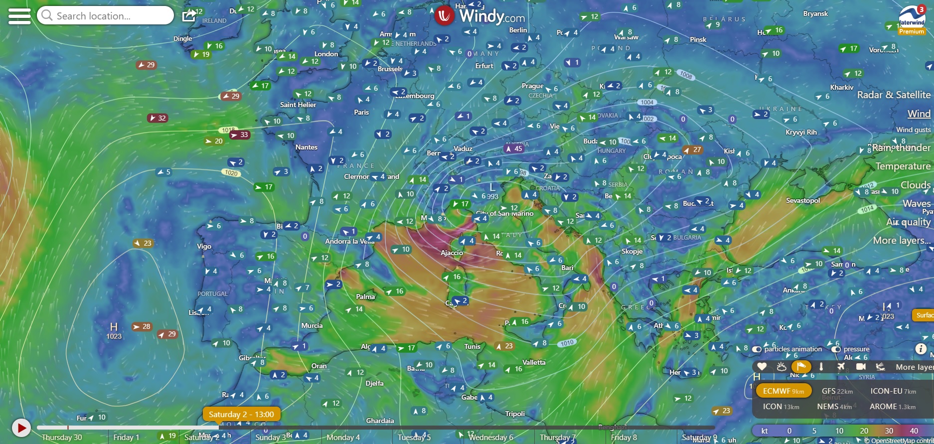
Between today 30/11 and Saturday 2/12 we will have the passage of an Atlantic disturbance, which will guarantee a lot of wind for riding. Here is the wind forecast to enjoy a beautiful day of windsurfing.
Forecast: sea and lakes of Como and Garda - 02-03/12/2023
Sea
On Friday 1 December, the disturbance will as usual attract air from the South along its eastern front, also significantly raising temperatures in some areas (19-20 degrees expected in Sicily and Sardinia). Libeccio/Ostro in Liguria, over the Grosseto area, in the Alghero area, in Western Sicily, over Calabria and the Salento peninsula (and also over Abruzzo, but offshore).

Saturday will be a beautiful windy day....
First of all, the spots in Southern France will work, from Gruissan to Saint Raphael, with a mistral that will tend to veer from the West, moving towards the East spots. Cannes is very uncertain as prediction. As already mentioned in the Waterwind forum, the call of air from the French inland, in this period of the year, leads to a drop in temperatures. In some spots (Coudouliere), the almost 40 knots expected will also lead to temperatures perceived around zero. Luckily, the sea water is still around 17 degrees.
The wind then, on Saturday, will continue strong, and will hit Corsica, and Sardinia (including the spots of Sinis, and those of Sant'Antioco, but not Chia, and up to Villasimius). Strong West over the Tyrrhenian coasts from Livorno to Naples and then to Sicily. It will be necessary to identify the spots that do not catch the wind completely onshore. Fairly significant swell everywhere. Again, Ostro (South) wind, Sun and 20 degrees in Puglia....
Quieter Sunday, with light north wind in the Marseille area (Boche du Rhone), in the Gulf of Genoa. Light mistral in Sardinia and Sicily (and Tyrrhenian Calabria). Bora (NE) in the Upper Adriatic, Tramontana in the Lower Adriatic.
Lakes Como and Garda
As already mentioned in the Waterwind forum, the Foehn will arrive over Lake Como on Saturday. The Foehn diagram is, at the moment, quite bad. Pressure difference Lugano - Zurich plummeting to -16 hPa and then rising significantly by Sunday midday .... With these promises, very gusty and strong wind is probable... Furthermore, the models give the wind peak between Lake Como and Lake Maggiore. On Garda, weather still disturbed, Saturday, and an uncertain day, with possible northerly winds, but of dubious quality.
Honestly, on both lakes I see better conditions on Sunday morning, with the good weather also returning. The cold has arrived on both lakes. Windchill near zero, water at 10-12 degrees. Maybe, at Pra, on Sunday morning at the car park, the temperature will, at least, be more acceptable.
If you ride, tell us in the forum how it was. If you have any further considerations, you can add them in the comments below.
Have a nice weekend. Fabio
Without your Support, Waterwind wouldn't exist. Become our supporter! If you want to advertise with us, read here, or contact us. Collaborate with us. Read here! Buy our Gadgets! Visit our YouTube channel!


