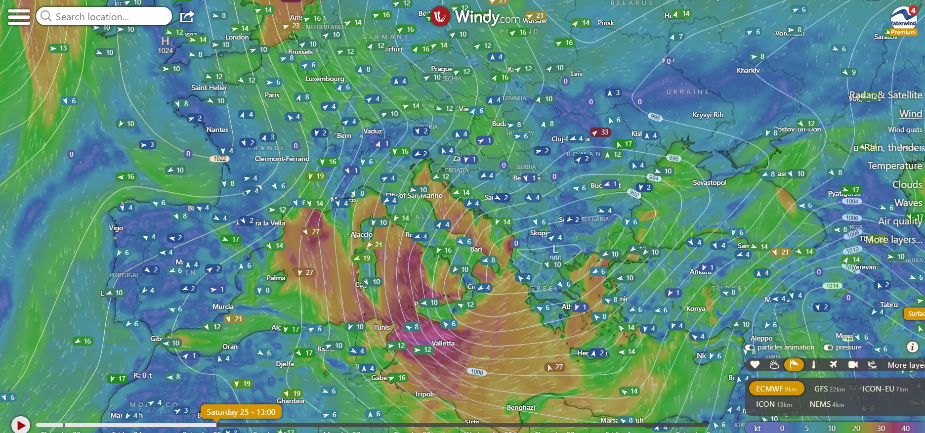
Weekend full of north winds, with an almost stormy Saturday. Here is the wind forecast to enjoy a beautiful day of windsurfing.
Forecast: sea and lakes of Como and Garda - 24-26/11/2023
Sea
On Friday 24th the Mistral will already begin to blow strongly over Southern France, to be honest with a strong component from the North. The Gruissan area will work; Carro could also offer rather beautiful conditions, with side/side-off wind, although it is unclear with how much high waves, being the first day of wind. The other spots in Marseille will also be working (Prado, Epluchures), and from just before sunset also the Coudou will give conditions.

Saturday will be a beautiful windy day....
First of all, the spots in Southern France, mentioned above, will continue to work, even if in the Gruissan area, the wind will be decidedly lighter. Instead, it promises to be of the right intensity at Carro, in Marseille, and at the Coudou. It will be fun. Hyeres, instead, won't be reached by the wind.
In Italy, on Saturday, the Tramontana will dominate the scene, almost everywhere. Tramontana over Sinis peninsula in Sardinia, with Funtana Meiga which could offer some epic hours in the afternoon. Then, going South Tramontana over the Sant'Antioco area: Sa Barra and the Maresciallo will work. But the Tramontana in Sardinia can also be caught on the East coast, and in particular in the Northern part. S'Ena and Sa Chitta should provide good conditions.
Tramontana side off also over the Lazio coast (also pay attention to Lake Bracciano) and down to Sicily, where it will blow really strong. The Stagnone, and for Wave lovers, Petrosino, should provide a great day. The Strait of Sicily will be also good.
But the Tramontana will also fully sweep a good part of the Adriatic coast from Ancona to Santa Maria di Leuca (with somewhat disturbed weather). North wind also throughout the Gulf of Taranto.
Sunday, substantial break, apart from WNW over the west coast of Sardinia and a light mistral over Puglia.
Lakes Como and Garda
As already mentioned in the forum, start of the North Foehn on Friday afternoon on Lake Como, which will continue on Saturday and Sunday too (attenuating), with a progressive drop in temperatures (but meteoswiss still gives highs around 14 degrees). The lower lake spots should also work.
Foehn, as you know, is not a friend of Garda, and therefore on Saturday and Sunday Peler would blow over Garda, anyway, but I fear it will be quite gusty and unstable.
If you ride, tell us in the forum how it went. If you have any further considerations, you can add them in the comments below.
Have a nice weekend. Fabio
Without your Support, Waterwind wouldn't exist. Become our supporter! If you want to advertise with us, read here, or contact us. Collaborate with us. Read here! Buy our Gadgets! Visit our YouTube channel!


